


Contact Info
Malheur National Forest
265 Hwy. 20 South
Hines, OR 97738
265 Hwy. 20 South
Hines, OR 97738
- Phone:
- 541-573-4300
Basics
- Length:
- 8 miles
- Difficulty:
- Difficult
- Time:
- 4.5 to 5.5 hours
- Trailhead Elevation:
- 4250 feet
- Elevation Range:
- 4250 feet to 4400 feet
- Elevation Change:
- 150 feet
- Usage:
- Light
- Season:
- April to November
Description
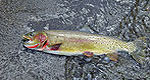
There is good fishing and wildlife viewing along this trail.
This trail follows along Pine Creek for a distance of 6 miles through steep canyon terrain.
Details
Length:
8 miles
Difficulty:
Difficult
Time:
4.5 to 5.5 hours
Trailhead Elevation:
4250
Elevation Range:
4250 feet to 4400
Elevation Change:
150
Usage:
Light
Season:
April to November
Map + Directions
Basic Directions
From Burns, travel 12 miles east on US Highway 20 turn left onto County Road 102 to Forest Service boundary where road becomes Forest Service road 28. Travel on Forest Service Road 28 to Forest Service Road 2850 and turn right. Travel 2 miles to Forest Service road 2855, turn right and go 3 miles. Signs will lead to the trailhead


