


Contact Info
The University of Montana
Missoula, MT 59812
- Phone:
- 406-243-6933
Basic Directions
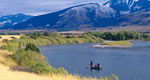
The Gunnison Gorge National Conservation Area (NCA) is located about seven miles northeast of Montrose in west central Colorado, just downstream from the Black Canyon of the Gunnison National Park It encompasses approximately 57,725 acres of public lands in Montrose and Delta counties.
DirectionsThe Gunnison Gorge NCA/Wilderness is located approximately 50 miles south of Grand Junction and just east off U.S. HWY 50 near the Town of Olathe. Falcon Road, east off HWY 50, about 10 miles north of Montrose and just south of Olathe, provides access from the north and southwest.
Delta County Road 2200, approximately 10 miles east of Delta on Colorado Highway 92 near Austin, also provides access to the NCA from the north. Follow the signs to Peach Valley Road and continue down Peach Valley until you come to the Chukar Road turnoff. Peach Valley also provides access to three other Wilderness trails - the Ute, Duncan, and Bobcat trails.
Description
The Gunnison Gorge Wilderness now contains a total of 17,700 acres and is managed by the Bureau of Land Management. All of the wilderness is in the state of Colorado.
Public land becomes wilderness through legislation passed by the United States Congress in the form of public laws. For the Gunnison Gorge Wilderness, this process began in 1999 when 17,700 acres were designated by Public Law 106-76.
The Gunnison Gorge Wilderness is part of the 106 million acre National Wilderness Preservation System. This System of wild lands contributes significantly to the ecological, economic, and social health of our country. Wilderness provides clean air and water, a shelter for endangered species, sacred places for indigenous peoples, a living laboratory for research, and a classroom for exploring personal values while experiencing risk, reward, and self-reliance. In wilderness, you can enjoy challenging recreational activities like hiking, backpacking, climbing, kayaking, canoeing, rafting, horse packing, bird watching, stargazing, and extraordinary opportunities for solitude.
Details
Additional Details:
River Canyon User Fees: User fees are required only in the Gunnison Gorge Wilderness Area and river canyon and only for individuals 16 years of age and older. Fees are currently set at $3.00/day/person for day use (in and out the same day) and $5.00/calendar day/person for overnight use (e.g. 1 night = $10 or 2 nights = $15 2 nights is maximum stay allowed in the wilderness). An annual day use pass is available for $15.00.
Campsite Use Regulations:
Camping within the river corridor is permitted in Designated Sites Only. A blue or green wooden post marks designated campsite locations with a white number. Blue Posted sites are for boaters only. Green Posted sites are for hikers only
All camping parties must register and reserve designated campsites.
The maximum group size limit for all campsites within the river corridor is 12 people.
The maximum stay length is two nights.
No wood fires are permitted. Stoves and/or fire pans with charcoal are mandatory for cooking.
Overnight groups with horses are required to stay at the designated Horse Campsite (#15 Ute 1/ Horse Camp) in Ute Park.
How to Register for a Campsite:
1.Select your preferred camp(s) from the river map. Boaters must camp in blue sites
Hikers must camp in green sites
2.Because users are registering at different starting points, it?s necessary to register and stick with the campsite you choose. Other wise you may displace another party or find yourself displaced.Check the Registration Form in the Visitor Registration Box to make sure another group has not reserved the camp you selected. Registration boxes for the Bobcat, Duncan and Ute Trails are located at the trailheads. The Chukar Box is located at the end of the Chukar Trail at the river.
3.Sign-in and enter your campsite number and /or name in the ?Reserved Campsite? box. Please be sure to supply all the information requested. Remember your campsite number and look for the post which marks its location in the Gorge. Overflow camps below the Smith Fork are marked so.


