


Contact Info
8975 Highway 2 East
P.O. Box 190340
Hungry Horse, MT 59919
- Phone:
- 406-387-3800
Basics
- Season:
- May to November
Basic Directions
Blankenship Bridge is your first access at the confluence of the North Fork Flathead River, followed upriver by: West Glacier, Moccasin, Cascadilla, Paola, Essex, and Bear Creek. Highway 2 provides excellent access along the lower river. For the more adventurous, an active airstrip and an administrative guard station can be found at Shafer Meadows. A backcountry Ranger is there to assist floaters and anglers. The Big River Trail No. 155, (Trailhead is at Bear Creek) is a good starting point for those on foot or horse. Anglers looking for less river traffic should avoid the 6 mile section between Moccasin and West Glacier as this is the most popular section for whitewater rafting.
Description
The Middle Fork Flathead River originates in the Bob Marshall Wilderness at the confluence of Strawberry and Bowl creeks. Better known for its whitewater than it’s fishing, the river is perhaps the best whitewater river in Montana, living up to its designation as a Wild and Scenic River under the 1976 Act. The upper 46 miles from its start to the confluence with Bear Creek is designated as "wild while the lower 49 miles to the confluence with the North Fork is designated as "recreational. Rapids with names such as "Jaws and "Bone-crusher provide sheer exhilaration. While in the more melancholic sections, it’s easy to get lost in the rhythm of the river as you breathe in the splendor of the scenery and the wildlife. Harlequin ducks, a spring and summer visitor to our country from the Pacific Coast, can often be seen along the river as they search for breeding sites.
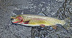
Fish in the Middle Fork run on the small size (8-12) because when the parent rock, argillite, breaks down it doesn’t contain much of the big fish producing nutrients that can be found in the productive limestone waters elsewhere in Montana. Secondly, these waters are cold, being fed by groundwater and glacier fed streams. However if you time your trip right, before spring runoff, you can catch larger westslope cutthroat trout that migrate from Flathead Lake on their spring spawning runs. Westslope cutthroat trout and bull trout in the Flathead River basin are adfluvial, that is they spend time in Flathead Lake rearing to adulthood until its time to spawn. Once they are sexually mature (4-6 years) they migrate into tributary streams, some migrations are over 100 miles, to spawn (cutthroat in the spring and bull trout in the fall). Once the fry emerge from the gravels, juveniles will rear in these tributaries for 1-3 years until they migrate back to Flathead Lake.
Adfluvial bull trout and westslope cutthroat from Flathead Lake have declined due to changes in the lakes food web. Opossum shrimp, mysis relicta, were planted in upstream lakes in 1967 and 1968. They drifted down rivers into Flathead Lake becoming established in the late 1970’s and peaking in the mid 1980’s. Mysis consumed the majority of zooplankton, thereby causing non-native kokanee salmon populations to crash due to starvation. Other fish, such as non-native lake trout and lake whitefish thrived in these conditions to the detriment of native fish. The food web in Flathead Lake is most likely still changing and it is difficult to predict what the outcome may be. A management plan for the lake and upper river system is in the works.
Fishing
Fish:
Cutthroat Trout
Rainbow Trout
Whitefish
Details
Season:
Camping Info
Additional Details:
Opening is the third Saturday in May through November 30, however, there is an extended catch and release season for trout and a 50 daily limit for whitefish for the rest of the year. The river is catch and release for cutthroat trout and a daily limit of 2 for rainbow trout. An angler needs to check the regulations as many tributary streams are closed to fishing to protect spawning bull trout and cutthroat trout. Note: It is illegal to take or intentionally fish for bull trout.
The best whitewater action can be found during and just after run-off in June and July. Fishing typically picks up in late July through September.


