


Contact Info
Airport Road
Lewistown, MT 59457
- Phone:
- 406-538-8706
Description
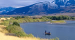
Extending 125 miles up the Missouri River from the Fort Peck Dam in north-central Montana, the Charles M. Russell National Wildlife Refuge (NWR) is approximately 1,100,000 acres in size and includes the 245,000 acre Fort Peck Reservoir. Given the size and remoteness of the Refuge, the area has changed very little from the historic voyage of Lewis and Clark through the era of outlaws and homesteaders. Visitors will find spectacular examples of native prairie, forested coulees, river bottoms, andbreaks badlands. Elk, mule deer, pronghorn, bighorn sheep, sage and sharp-tailed grouse, and bald eagles make the Refuge home. The Refuge's namesake famously portrayed this rich diversity of native wildlife and habitats in many of his paintings. UL Bend NWR, a refuge-within-a-refuge, lies within Charles M. Russell NWR and contains 20,000 acres of designated wilderness. UL Bend NWR is the site of an ongoing effort to rescue one of North America's most endangered animals, the black-footed ferret. Large black-tailed prairie dog towns, on which ferrets depend, are concentrated on the Refuge. Magnificent sage grouse displays can be seen in early spring as birds gather on traditional leks to breed. The Refuge Complex also contains Hailstone, Halfbreed, Lake Mason, and War Horse National Wildlife Refuges. These small satellite Refuges are scattered throughout central Montana and were established primarily to protect wetlands for migratory birds and waterfowl. Several Waterfowl Production Areas are also managed as part of the Refuge Complex. Hunting and fishing opportunities abound on Charles M. Russell NWR, its satellite Refuges, and the Waterfowl Production Areas. Boating is popular on the Missouri River and Fort Peck Reservoir. Several state parks and recreational areas have been developed within the Refuge. Each fall, hundreds of elk congregate in the Slippery Ann Wildlife Viewing Area, creating a spectacle not to be missed. Camping is permitted anywhere on the Refuge. The entire Refuge is open to hiking and horseback riding although no formal trails exist. Wildlife viewing and photography opportunities are found throughout the Refuge.
Map + Directions
Basic Directions
Charles M. Russell NWR is located about 150 miles northeast of Billings, Montana. The headquarters for the Refuge Complex is located in Lewistown. From Great Falls, follow U.S. Highway 87 east for 100 miles to Lewistown. Turn right onto Airport Road. From Billings, follow U.S. Highway 87 north to Grass Range and then west to Lewistown for 130 miles. Turn left onto Airport Road. The Refuge headquarters is located about 1 mile up the road to the left. Three staffed field stations are located around the Refuge. Sand Creek Wildlife Station is located 2 miles south of the Missouri River on the east side of U.S. Highway 191. Jordan Wildlife Station is located south of Montana Highway 200 in the town of Jordan. Fort Peck Wildlife Station is located east of Montana Highway 24 in the town of Fort Peck.


