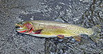
Anita Dam and Reservoir, features of the Huntley Project, are located 6 miles southeast of Ballantine, Montana near Billings. This offstream storage dam was completed by the Civilian Conservation Corps in 1937. Water is released from Anita Reservoir into the Reservoir Canal which flows across Fly Creek to the vicinity of Pompeys Pillar . As the first representative of the United States in the Upper Missouri Valley, Captain Clark of the Lewis and Clark expedition scratched his name and the date of July 25, 1806 on Pompeys Pillar, a large rock landmark overlooking the Yellowstone River. The Crow Indian Reservation and the Little Bighorn Battlefield National Monument are nearby. The Anita Reservoir, with 32 surface acres and 2 miles of shoreline, offers seasonal opportunities for crappie, catfish, and largemouth bass. No facilities are available.
IdahoStart planning your Idaho adventure. Vacation is more than just scenery; it’s about making life long memories. Download or order the free Idaho Travel Guide here. Request this Free Visitor GuideRequested!You're all set! Complete the form below to receive your guides by mail.
We also have the following visitor guides in Montana. Click on any additional guides you would like to receive.
Visit Idaho Idaho
Visit Idaho
IdahoStart planning your Idaho adventure. Vacation is more than just scenery; it’s about making life long memories. Download or order the free Idaho Travel Guide here. Request this Free Visitor GuideRequested!You're all set! Complete the form below to receive your guides by mail.
We also have visitor guides available in states highlighted in blue below. Click on any state to see what's available.
Alaska
Arizona
California
Canada
Colorado
Hawaii
Idaho
Louisiana
Michigan
Montana
Nevada
New Mexico
Ohio
Oregon
Texas
Utah
Washington
Wyoming
Switch to Mobile Browser Mode
We offer a compact version of Go-Montana for mobile users, allowing you to access just the information you need on the road. Of course, you can still use the full version of Go-Montana on your mobile device just as you can on your desktop.