


Contact Info
8975 Highway 2 East
P.O. Box 190340
Hungry Horse, MT 59919
- Phone:
- 406-387-3800
Basics
- Season:
- Year round
Description
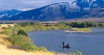
Hungry Horse Reservoir is a 23,813 acre impoundment that was created in 1953 after the construction of Hungry Horse Dam, the upper most dam in the Columbia River Hydro-power system. Hungry Horse Reservoir is managed for flood control and power production thus draw downs are common. Prior to the dam, the South Fork Flathead River was connected to the Flathead River system. Bull trout and westslope cutthroat trout would migrate from Flathead Lake to spawn and rear in South, Middle and North Fork tributary streams. Construction of the dam blocked upstream passage and 40% of the available spawning area for these fish. There was no consideration for fish passage in the construction of the dam. Fish from the South Fork can no longer return to Flathead Lake but use the reservoir to rear and reach maturity. Hungry Horse Reservoir and the South Fork Flathead River basin are extremely unique. The watershed is one of few watersheds in the West were exotic species such as brook, brown and rainbow trout are not common. Brook and brown trout are entirely absent while some rainbow and hybrid cutthroat populations exist in high mountain lakes that drain into western tributaries of Hungry Horse Reservoir. We are currently working with Montana Department of Fish, Wildlife, & Parks to reduce these threats to native fish. We cannot over-emphasize the importance of preventing invasion of exotic species. Exotic species often out-compete, prey upon, or hybridize with native fish and are often the single most factor influencing our native fisheries. Fishery populations are currently very strong. The South Fork Flathead is one of a handful of watersheds in Montana where bull trout populations are healthy. The reservoir receives very little angling pressure and the many hidden bays can provide you with the solitude that you cannot find on larger water bodies.
Fishing
Fish:
Cutthroat Trout
Whitefish
Details
Season:
Camping Info
Amenities
Map + Directions
Basic Directions
Forest Roads No. 38 and No. 895 are your access points. Road No. 895 takes you along the Westside of the reservoir and passes you over the 564' Hungry Horse Dam. The first 11 miles to the Lid Creek Campground are paved. Road No. 38 takes you along the eastside of the reservoir and is the primary route if you intend to travel to the upper end of the reservoir near Spotted Bear. Note: there is no gas and limited services (3 guest ranches) at Spotted Bear. There are 10 boat ramps along the reservoir. Abbot Bay, on the eastside, is the longest that will get you on the water when the reservoir is down to 130'. Lost Johnny Point is the longest (73') on the west side.